
I’ve really been getting into my coastal hikes recently, so hitting the Camí de Cavalls on my trip to Menorca was a no-brainer. Some islands are blessed with trails that take you from coast to coast, but this one takes you all the way around the island.
It was originally used by soldiers on horseback and dates back as far as the 14th century. Total length is 185km and you can walk it in around 10 days.
Unfortunately, I didn’t have enough time to attempt the whole thing, plus my knees are a bit cranky at the moment, but I thought I’d find a few of the more scenic day hikes to work into my schedule.
Hiking Stages of the Camí de Cavalls by Bus
Most of the information I found online was for people aiming to tackle the whole loop, or do it in stages. I just wanted to find a couple of hikes of around 2-4 hours, accessible by public transport, without switching up hotels.
I originally planned to stay in Cala Galdana as the scenery around there is beautiful. But it turned out that Ciutadella was a better base for reaching places by public transport as it’s a main hub for buses. This is also true of the buses from Mahon, but I was more drawn to the south-west coast for this trip.
Whilst I was browsing a bookstore one day I came across Lonely Planet – Day Hikes in Spain, which covers 3 different walks on the Camí de Cavalls and gave me a bit of a headstart with my planning. If you visit Spain frequently it’s a nice book for a bit of inspiration; it also features a few hikes on Mallorca.

After reading this book I didn’t feel the need to buy a special guidebook for the whole trail, but if you want one the main guide is The Cami de Cavalls: The Tour of Menorca in 10 Days (Guide & Map). It’s also available in nearly every tourist shop on the island. If you want to make the most of any sites of interest on the route then it’s a good buy.
(Also pictured is Wild Guide – Balearic Islands, no walking directions in here but it’s a pretty thorough guide to beaches and beauty spots with parking/access information.)
One thing I often find about hiking guidebooks is that the stages are sometimes longer than I prefer to walk, or don’t make any sense for public transport, or don’t take into account my speed (a leisurely dawdle) or detours for food. I’m not a hardcore hiker and look for suggested hikes of 2-4 hours.
If you’re looking for something more challenging, check out the stage suggestions on Camí de Cavalls 360 website or Descobreix Menorca.
I used Komoot app whilst walking.

One thing to bear in mind is that bus schedules to the beach areas are very seasonal. In the winter, you’ll struggle as most don’t run at all. In the summer, there are extra routes to the popular beaches as well as increased frequency to the resorts.
During the spring and autumn, the bus timetables can change week to week. Services on a Sunday are reduced. I found the Consell Insular de Menorca website useful as you can find timetables for previous years which can help with the guesswork.
Here I’ve marked ** next to the stages which are safer bets for buses earlier/later in the season.
From my research, it seemed that the stages you can do by bus from Ciutadella are:
- Son Bou – Sant Tomàs – 6.5km (change of bus in Alaior)
- Sant Tomàs to Cala Galdana – 11km
- Cala Galdana to Cala en Bosc** – 13km
- Cala en Bosc to Ciutadella** – 13km
- Cala Morell to Ciutadella** – 19km
If you’re staying in Cala Galdana and want to hike in either direction from there:
- change in Ferreries for the bus to Sant Tomàs and walk back from there
- take the beach boat to Cala Turqueta and walk back from there
- take the beach boat to Son Saura and walk back from there
- bonus – it’s not part of the Camí de Cavalls but you can take a bus to Ferreries and hike back down to Cala Galdana along the Barranc d’Algendar ravine (7km).
The stages that you can do by bus from Mahon are:
- Es Grau – Mahon – 10km
- Mahon – Punta Prima – 13km (all road between Mahon and Cala Sant Esteve/Fort Marlborough)
- Punta Prima – Binissafuller – 8km (mostly road)
- Binissafuller – Cala en Porter – 12km
- Cala en Porter – Son Bou – 8km
- Son Bou – Sant Tomàs – 6.5km (change bus in Alaiors)
The north coast is much harder to do by bus, especially outside the summer, but if you’re used to long remote hikes you might be able to cobble together something using the Auto Fornells bus routes. There are no buses west of Fornells.
You can book a guided group walk with bus transfers from Favaritx to Es Grau on Getyourguide for £34.
For most of the routes, the terrain itself is rocky but fairly easy with just a small amount of elevation gain when you need to go up/down to sea level. The more challenging stages are the ones you can’t reach by bus. But some of the stretches are remote with few facilities or shade, and the bits around the cities tend to be on roads which can be busy in the summer.
Don’t forget to take all of your rubbish with you and close any gates behind you (Menorca is an agricultural island with lots of grazing animals).
Hiking Cala Galdana to Son Xoriguer/Cala en Bosc
I visited Menorca in early May so the bus services to the main beach areas were running but still fairly infrequent. The easiest walk to plan was Cala Galdana to Son Xoriguer. I was in Cala Galdana just after 10am – and that was the first bus of the day. Strangely, there aren’t that many places to eat in Cala Galdana. I guess most people eat in the big hotels. I did manage to find something at Tobogán. There’s a mini market nearby for supplies, and it’s close to the start of the trail.

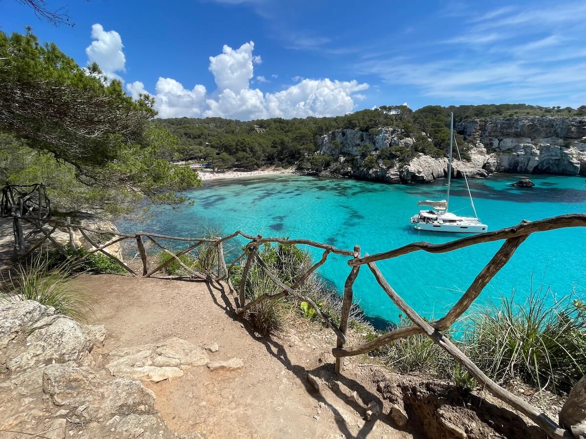
The first bit of the path takes you to the stunning nearby Cala Macarella and Macarelleta. These are two of the most beautiful beaches in Menorca, perhaps even all of Spain. So this is a popular walk. Despite that, I still found one bit which wasn’t well signposted. Perhaps because there are actually a few different routes you can take.
The steepest bit of the hike is this bit at the beginning; it gets progressively flatter and more barren the further west you get. I did manage a quick swim at Cala Macarelleta but it was unpleasantly busy so I didn’t linger. All of the beaches around Cala Galdana were busy even in early May (I can’t imagine what they’re like in the summer) but most of the others have a bit more space.
Cala Turqueta is the next beach. It’s also a stunner, a bit busier than I was expecting. I ate my lunch here. There’s another smaller beach a bit further on called Cala Talaier.

Son Saura was the first quiet beach I reached but, unfortunately, it had clouded over by that point. Son Saura is a wide sandy beach with shallow waters and a long boardwalk. It has more space to absorb people but it does get busy when the excursion boats stop here. It also has a lot of posidonia (Neptune’s Grass). This stuff is amazing for the ecosystem – you’ll see it a lot around Menorca as the island is very good at looking after its environment. It cleans the water and keeps it crystal clear, and also contributes to the soft sand. But there’s no denying it’s less appealing to swim in the stuff – probably a good thing for the sea that it keeps humans away too! There’s more of it about after the winter storms.
At each main beach, you’ll find an information board, parking, and toilets, but outside the summer peak there’s nowhere to buy food or water, so don’t forget those snacks.


After Son Saura, the coastline becomes rocky and rugged with no trees for shelter. It looks more like Malta than the typical postcard image of Menorca. You’ll walk past a few small calas and some bunkers from the Civil War, but otherwise this last stretch is a bit of a slog.
The hike ends in Son Xoriguer/Cala en Bosc (two resort areas merged into one). There are a couple of bus stops here. There’s a cafe when you first get to Son Xoriguer, but walk a bit further on to Cala en Bosc and you’ll find a variety of places to eat, drink and shop around the man-made harbour. It’s a good place to grab dinner. I was looking a bit wild and windswept by the time I finished though, so I just got on the bus home. But on another day, I had really Peruvian food at Kaypa Origen Peru inside the Lago Resort Menorca.
Hiking Cala Galdana to Cala Mitjana and Mitjaneta
I planned to hike the whole section to Sant Tomàs but the weather had other plans. I’ll try to update this after my next trip. In the end I went to Cala Galdana and managed the walk to nearby Cala Mitjana and Cala Mitjaneta before the rain started up. This is a really nice walk – short but steep and through shady pine forest up and back down to the sea. The beaches are busy as they’re so close to Cala Galdana, . You don’t need a map for this, just find the start of the trail which is at the top of the town, then follow the path and the crowds down to the beaches.

The sea here is a stunning, such an intense shade of turquoise. I had a lovely dip at the smaller cove Cala Mitjaneta. You need to clamber down a few steps to get to the tiny beach here. Cala Mitjana requires less clambering, and is a bigger beach.
The next beach along is Cala Trebaluger. If you want to walk here it’s 3km from Cala Galdana, but you’ll have to return the same way.
There are several beaches around Sant Tomàs that you can’t drive to, so it’s a better bet for getting away from the crowds than the beaches west of Cala Galdana.
Hiking Cala en Bosc or Cala Morells to Ciutadella
Both Cala en Bosc and Cala Morells are inside Ciutadella’s suburban zone, so buses are plentiful. Both have long stretches of barren landscape with no shade. On both walks, you’ll come across pretty calas surrounded by resort sprawl.
- Cala Morells to Ciutadella: 19km of easy walking but a harsh, desolate landscape with no amenities until you reach Cala en Blanes. Then roads to Ciutadella.
- Cala en Bosc to Ciutadella: 13km with a few of those along a flat but rocky coastal path and the rest along roads through residential areas.

Hiking Transfers
If you don’t want to DIY with public transport, there are several companies on the island which can arrange transfers, sherpa services and guided walks such as:
Read more about Menorca:
Menorca – Complete Beach Resort Guide
Old and Beautiful: Ciutadella City Guide